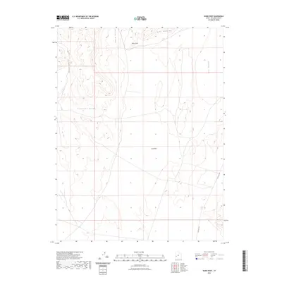
2023 Map of Warm Point
USGS Topo · Published 2023About this map
Warm Point and the surrounding high desert of Millard County are defined by dramatic topographical shifts and arid drainage patterns. This 2023 survey illustrates the western reaches of the Confusion Range and the northern extent of the Barn Hills, where the land drops into the broad expanse of Tule Valley. The corridor is dominated by north-south orientations, carved by Smooth Canyon and Blind Valley. A significant landscape feature, Sand Wash, cuts across the central basins, indicating the seasonal water movement that shapes this environment. Human presence is minimal and primarily reflected in the path of Tule Valley Rd, which provides the only major navigational access through this remote section of the Great Basin.
Find a feature on this map
8 named features on this map. Tap any name to fly to it.
Don’t see what you’re looking for? This feature index may not catch every label — zoom into the map to look around manually.
Map Details
Editions of this 2023 Warm Point Map
This is the sole edition of this map. No revisions or reprints were ever made.
Other maps of this area

1953 · Richfield
USGS Topo · 1:250,000

1958 · Richfield
USGS Topo · 1:250,000

1960 · Frisco Peak
USGS Topo · 1:62,500

1960 · Wah Wah Summit
USGS Topo · 1:62,500

1960 · Crystal Peak
USGS Topo · 1:62,500

1960 · The Barn
USGS Topo · 1:62,500

1980 · Wah Wah Mts. North
USGS Topo · 1:100,000
1989 · Brown Knoll
USGS Topo · 1:24,000
1989 · Fifteenmile Point
USGS Topo · 1:24,000
1989 · Grassy Cove
USGS Topo · 1:24,000