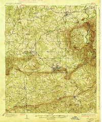
1936 Map of Warm Springs
USGS Topo · Published 1936About this map
Warm Springs Foundation and its surroundings serve as the centerpiece of this mid-1930s survey, illustrating a landscape defined by the convergence of therapeutic mineral waters and major transportation infrastructure. The area, famously frequented by Franklin D. Roosevelt, is shown just as the F. D. Roosevelt Highway was becoming a vital artery through the southern Piedmont. The map documents the industrial and medical importance of the region, from the US Fish Hatchery and Warm Springs Landing Field to the bustling rail junction at Manchester.
Find a feature on this map
102 named features on this map. Tap any name to fly to it.
Don’t see what you’re looking for? This feature index may not catch every label — zoom into the map to look around manually.
Map Details
Editions of this 1936 Warm Springs Map
4 editions found
Other maps of this area

1907 · Talbotton
USGS Topo · 1:125,000

1934 · Warm Springs
USGS Topo · 1:62,500

1935 · Thomaston
USGS Topo · 1:48,000

1936 · Warm Springs
USGS Topo · 1:62,500

1939 · Thomaston
USGS Topo · 1:62,500

1950 · Talbotton
USGS Topo · 1:24,000

1950 · Waverly Hall
USGS Topo · 1:24,000

1950 · Cataula
USGS Topo · 1:24,000

1950 · Talbotton
USGS Topo · 1:62,500

1950 · Ellerslie
USGS Topo · 1:62,500