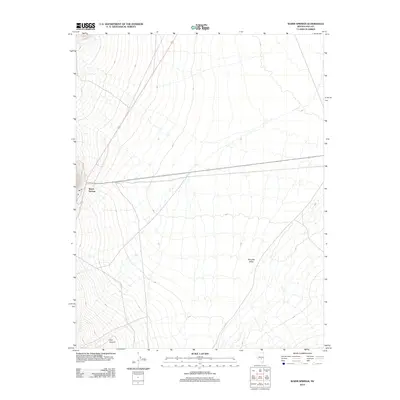
2012 Map of Warm Springs
USGS Topo · Published 2012About this map
Warm Springs serves as the focal point for this 2012 survey of a remote Nye County crossroads. Situated at the junction of two primary routes, the settlement is positioned near the expansive Reveille Valley, a landscape defined by its wide, open basin and subtle drainage patterns. The topography transitions toward the southwest as the terrain ascends into the more defined landforms of Cow Canyon, also labeled on this sheet as Cow Cyn. This map provides a clear view of the sparse infrastructure and natural features of the high desert before the turn of the decade, showing the primary highway access and the seasonal watercourses that drain the surrounding basins.
Find a feature on this map
4 named features on this map. Tap any name to fly to it.
Don’t see what you’re looking for? This feature index may not catch every label — zoom into the map to look around manually.
Map Details
Editions of this 2012 Warm Springs Map
This is the sole edition of this map. No revisions or reprints were ever made.
Other maps of this area

1956 · Tonopah
USGS Topo · 1:250,000

1959 · Tonopah
USGS Topo · 1:250,000

1962 · Tonopah
USGS Topo · 1:250,000

1967 · Lunar Crater
USGS Topo · 1:62,500

1967 · Buckwheat Rim
USGS Topo · 1:24,000

1967 · Tybo SE
USGS Topo · 1:24,000

1968 · Tybo
USGS Topo · 1:62,500

1968 · Warm Springs
USGS Topo · 1:62,500
1968 · Reveille
USGS Topo · 1:62,500
1968 · Warm Springs NW
USGS Topo · 1:24,000