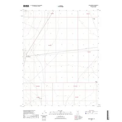
2018 Map of Warm Springs
USGS Topo · Published 2018About this map
Warm Springs serves as a lone point of habitation at the junction of Highway 6 and Highway 375, situated where the desert basins of central Nevada converge. This high-desert landscape is defined by the hydrologic contrast of the Hot Spring near the settlement and the dry expanses of Hot Creek Valley and Reveille Valley. The terrain is marked by the transition between these open valleys and the more broken ground of Cow Canyon to the south. The mapping reveals a sparse infrastructure, typical of the remote Great Basin, where transportation routes follow the natural corridors between arid basins. This survey provides a precise view of the geographic isolation and the critical importance of water sources in a region dominated by vast open ranges and section line boundaries.
Find a feature on this map
15 named features on this map. Tap any name to fly to it.
Don’t see what you’re looking for? This feature index may not catch every label — zoom into the map to look around manually.
Map Details
Editions of this 2018 Warm Springs Map
This is the sole edition of this map. No revisions or reprints were ever made.
Other maps of this area

1956 · Tonopah
USGS Topo · 1:250,000

1959 · Tonopah
USGS Topo · 1:250,000

1962 · Tonopah
USGS Topo · 1:250,000

1967 · Lunar Crater
USGS Topo · 1:62,500

1967 · Buckwheat Rim
USGS Topo · 1:24,000

1967 · Tybo SE
USGS Topo · 1:24,000

1968 · Tybo
USGS Topo · 1:62,500

1968 · Warm Springs
USGS Topo · 1:62,500
1968 · Reveille
USGS Topo · 1:62,500
1968 · Warm Springs NW
USGS Topo · 1:24,000