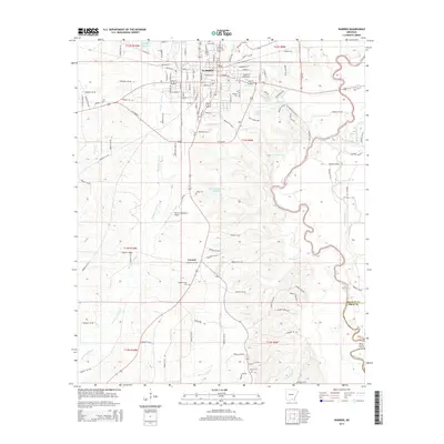
2014 Map of Warren
USGS Topo · Published 2014About this map
Warren serves as the central hub of this Bradley County landscape, where an intricate grid of streets like W Pine St and E Church St gives way to the dense hydrography of the Arkansas timberlands. The town is flanked by a significant concentration of local burial sites, including Union Cem, Oakland Cem, and Saline Cem, which provide essential touchpoints for genealogical research. To the south, the settlement of Carmel sits near the Warren Municipal Airport, marking the transition into a landscape dominated by the winding course of the Saline River. This river system, with its associated backwaters such as Gin House Slough, Log Slough, and Old River, highlights the low-lying, water-defined geography of the region. Notable water bodies like Bradley County Lake and Warren Country Club Lake punctuate the terrain, illustrating the local reliance on both natural and managed water resources.
Find a feature on this map
133 named features on this map. Tap any name to fly to it.
Don’t see what you’re looking for? This feature index may not catch every label — zoom into the map to look around manually.
Map Details
Editions of this 2014 Warren Map
This is the sole edition of this map. No revisions or reprints were ever made.
Other maps of this area

1934 · Ingalls
USGS Topo · 1:48,000

1937 · Ingalls
USGS Topo · 1:62,500

1939 · Ingalls
USGS Topo · 1:62,500

1953 · Greenwood
USGS Topo · 1:250,000

1953 · El Dorado
USGS Topo · 1:250,000

1956 · Greenwood
USGS Topo · 1:250,000

1957 · El Dorado
USGS Topo · 1:250,000

1958 · El Dorado
USGS Topo · 1:250,000

1960 · El Dorado
USGS Topo · 1:250,000
1971 · Hermitage
USGS Topo · 1:24,000