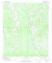
1971 Map of Hermitage
USGS Topo · Published 1973About this map
Hermitage serves as the central hub of this 1971 survey in Bradley County, where the Chicago Rock Island and Pacific railroad cuts a diagonal line through the timber and river bottoms. The landscape is defined by the winding course of L'Aigle Creek and its tributary Brushy L'Aigle Creek, which eventually give way to the broader Saline River in the northeast. This era shows a community structured around rural intersections and resource extraction, evidenced by numerous Gravel Pits scattered across the terrain.
Find a feature on this map
21 named features on this map. Tap any name to fly to it.
Don’t see what you’re looking for? This feature index may not catch every label — zoom into the map to look around manually.
Map Details
Editions of this 1971 Hermitage Map
2 editions found
Other maps of this area

1934 · Ingalls
USGS Topo · 1:48,000

1934 · Moro Bay
USGS Topo · 1:62,500

1937 · Ingalls
USGS Topo · 1:62,500

1938 · Moro Bay
USGS Topo · 1:62,500

1939 · Moro Bay
USGS Topo · 1:62,500

1939 · Ingalls
USGS Topo · 1:62,500

1953 · El Dorado
USGS Topo · 1:250,000

1957 · El Dorado
USGS Topo · 1:250,000

1958 · El Dorado
USGS Topo · 1:250,000

1960 · El Dorado
USGS Topo · 1:250,000