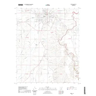
2020 Map of Warren
USGS Topo · Published 2020About this map
Warren serves as the focal point of this Bradley County landscape, centered around the Bradley County Courthouse and a dense network of city streets including W Pine St and E Church St. The town's layout is bounded by the winding Saline River to the east and Brushy L'Aigle Cr to the west. This survey captures the region's balance between municipal development and its creek-fed bottomlands. Outside the city center, the small settlement of Carmel lies to the south, surrounded by several family and community burial grounds such as Adams/Singer Cem and Coker Cem. The presence of the Warren Municipal Airport and the Warren Country Club Lake highlights the modern infrastructure and recreational spaces established in this timber-rich pocket of southern Arkansas.
Find a feature on this map
136 named features on this map. Tap any name to fly to it.
Don’t see what you’re looking for? This feature index may not catch every label — zoom into the map to look around manually.
Map Details
Editions of this 2020 Warren Map
This is the sole edition of this map. No revisions or reprints were ever made.
Other maps of this area

1934 · Ingalls
USGS Topo · 1:48,000

1937 · Ingalls
USGS Topo · 1:62,500

1939 · Ingalls
USGS Topo · 1:62,500

1953 · Greenwood
USGS Topo · 1:250,000

1953 · El Dorado
USGS Topo · 1:250,000

1956 · Greenwood
USGS Topo · 1:250,000

1957 · El Dorado
USGS Topo · 1:250,000

1958 · El Dorado
USGS Topo · 1:250,000

1960 · El Dorado
USGS Topo · 1:250,000
1971 · Hermitage
USGS Topo · 1:24,000