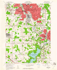
1959 Map of Warren
USGS Topo · Published 1961About this map
The Mahoning River carves a deep industrial and residential path through this late-1950s Ohio landscape, anchoring the bustling centers of Warren and Niles. This era represents a peak of heavy infrastructure, shown by the complex rail networks of the Erie Lackawanna RR, Baltimore and Ohio RR, and Pennsylvania RR that converge at strategic points like DeForest Junction and Niles Junction. To the south, the massive Meander Creek Reservoir dominates the terrain, while the Lordstown Military Reservation occupies a significant tract to the west.
Find a feature on this map
145 named features on this map. Tap any name to fly to it.
Don’t see what you’re looking for? This feature index may not catch every label — zoom into the map to look around manually.
Map Details
Editions of this 1959 Warren Map
4 editions found
Other maps of this area

1905 · Bristolville
USGS Topo · 1:62,500

1906 · Youngstown
USGS Topo · 1:62,500

1907 · Kinsman
USGS Topo · 1:62,500

1907 · Bristolville
USGS Topo · 1:62,500

1908 · Youngstown
USGS Topo · 1:62,500

1908 · Warren
USGS Topo · 1:62,500

1950 · Cleveland
USGS Topo · 1:250,000

1951 · Youngstown
USGS Topo · 1:24,000

1952 · Lake Milton
USGS Topo · 1:24,000

1952 · Canfield
USGS Topo · 1:24,000
Featured Places
- Warren, OH
- Weathersfield Township, OH
- Howland Township, OH
- Niles, Weathersfield Township
- Warren Township, OH