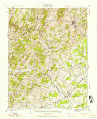
1927 Map of Warrenton
USGS Topo · Published 1958About this map
The Rappahannock River forms a jagged natural boundary between Fauquier and Culpeper counties on this late 1920s survey. At the heart of the region, Warrenton serves as a primary hub, with local estates like Alwington and the waters of Fauquier White Sulphur Springs defining the social landscape of the Piedmont. The agricultural character of the era is evident in the high density of rural schoolhouses and neighborhood churches, such as Litchfield Sch and Wesley Chapel, which were the anchors of small farming communities like Orlean and Lakota.
Find a feature on this map
55 named features on this map. Tap any name to fly to it.
Don’t see what you’re looking for? This feature index may not catch every label — zoom into the map to look around manually.
Map Details
Editions of this 1927 Warrenton Map
4 editions found

Other maps of this area

1887 · Spottsylvania
USGS Topo · 1:125,000

1892 · Spottsylvania
USGS Topo · 1:125,000

1892 · Gordonsville
USGS Topo · 1:125,000

1893 · Luray
USGS Topo · 1:125,000

1894 · Warrenton
USGS Topo · 1:125,000

1894 · Warrenton
USGS Topo · 1:62,500

1905 · Luray
USGS Topo · 1:125,000

1927 · Remington
USGS Topo · 1:48,000

1930 · Warrenton
USGS Topo · 1:62,500

1933 · Middleburg
USGS Topo · 1:62,500