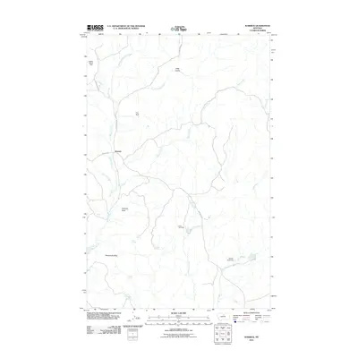
2011 Map of Warrick
USGS Topo · Published 2011About this map
Warrick sits at the junction of several rural routes including Warrick Rd and Clear Creek Rd, serving as a central point in this high-plains landscape. The drainage system is defined by the diverging branches of West Fork Birch Creek and East Fork Birch Creek, which eventually feed into the main Birch Creek channel. The terrain is punctuated by distinctive geological landmarks such as Haystack Butte and Rattlesnake Butte, while water management is evidenced by small-scale impoundments like Dies Irae Dam and Paddle Board Dam. This 2011 survey captures a network of spring-fed resources, including Cecil Spring and Polish Spring, which remain vital landmarks for local land use and genealogy in this corner of Chouteau County.
Find a feature on this map
24 named features on this map. Tap any name to fly to it.
Don’t see what you’re looking for? This feature index may not catch every label — zoom into the map to look around manually.
Map Details
Editions of this 2011 Warrick Map
This is the sole edition of this map. No revisions or reprints were ever made.
Other maps of this area

1953 · Havre
USGS Topo · 1:250,000

1954 · Lewistown
USGS Topo · 1:250,000

1956 · Maddux
USGS Topo · 1:62,500

1957 · Havre
USGS Topo · 1:250,000

1958 · Havre
USGS Topo · 1:250,000

1959 · Lewistown
USGS Topo · 1:250,000

1959 · Warrick
USGS Topo · 1:62,500
1984 · Eskay NE
USGS Topo · 1:24,000

1984 · Big John Butte
USGS Topo · 1:24,000
1984 · Warrick
USGS Topo · 1:24,000