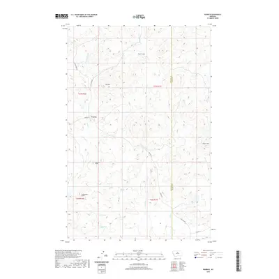
2020 Map of Warrick
USGS Topo · Published 2020About this map
Warrick sits within a landscape defined by significant topographic landmarks and a network of isolated water sources along the border of Chouteau and Blaine Counties. High points such as Haystack Butte, Rattlesnake Butte, and Elkhorn Mtn dominate the horizon, while smaller features like The Rock and Hatje Coulee provide local waypoints across the ranching country. The area is notably dependent on numerous named springs, including Bills Spring, Juniper Spring, Polish Spring, and Gasparage Spring, which historically supported the region's livestock and early residents. Access to these remote reaches is maintained by a series of gravel and unimproved roads, most notably Warrick Rd and Sand Creek Rd, tracing the drainage patterns of Rhue Cr, Sand Cr, and the forks of Birch Cr.
Find a feature on this map
27 named features on this map. Tap any name to fly to it.
Don’t see what you’re looking for? This feature index may not catch every label — zoom into the map to look around manually.
Map Details
Editions of this 2020 Warrick Map
This is the sole edition of this map. No revisions or reprints were ever made.
Other maps of this area

1953 · Havre
USGS Topo · 1:250,000

1954 · Lewistown
USGS Topo · 1:250,000

1956 · Maddux
USGS Topo · 1:62,500

1957 · Havre
USGS Topo · 1:250,000

1958 · Havre
USGS Topo · 1:250,000

1959 · Lewistown
USGS Topo · 1:250,000

1959 · Warrick
USGS Topo · 1:62,500
1984 · Eskay NE
USGS Topo · 1:24,000

1984 · Big John Butte
USGS Topo · 1:24,000
1984 · Warrick
USGS Topo · 1:24,000