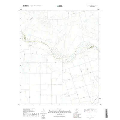
2019 Map of Warrior Hollow
USGS Topo · Published 2019About this map
The Pease River meanders across this rural expanse of the Texas Panhandle, marking the natural boundary between Hardeman and Foard counties. The landscape is defined by the broad, sandy bed of the river and the dramatic incision of Warrior Hollow to the north. A network of rural routes, including N Fm 98 and Sandy Rd, connects the scattered agricultural holdings of the region. Local history is anchored by the presence of Margaret Cem and Thalia Cem, which serve as quiet landmarks for the families who have long worked this semi-arid terrain. The drainage patterns of Mule Cr further illustrate the topographical character of the plains as they break toward the river valley.
Find a feature on this map
31 named features on this map. Tap any name to fly to it.
Don’t see what you’re looking for? This feature index may not catch every label — zoom into the map to look around manually.
Map Details
Editions of this 2019 Warrior Hollow Map
This is the sole edition of this map. No revisions or reprints were ever made.
Other maps of this area

1954 · Wichita Falls
USGS Topo · 1:250,000

1955 · Lawton
USGS Topo · 1:250,000

1958 · Wichita Falls
USGS Topo · 1:250,000

1958 · Vernon
USGS Topo · 1:62,500

1958 · Medicine Mound
USGS Topo · 1:62,500

1966 · Crowell
USGS Topo · 1:24,000

1966 · Thalia
USGS Topo · 1:24,000
1966 · Santa Rosa Lake NW
USGS Topo · 1:24,000

1983 · Warrior Hollow
USGS Topo · 1:24,000

1983 · Tolbert
USGS Topo · 1:24,000