
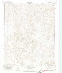
1972 Map of Washburn Arroyo
USGS Topo · Published 1974About this map
Washburn Arroyo carves through the Panhandle landscape along the border of Roberts and Hemphill counties, revealing a mid-century industrial profile focused on energy extraction. This 1972 field-checked survey highlights a dense network of infrastructure, where numerous Gas Wells and Oil Wells are connected by an extensive Pipeline system. In the southeast corner, the Atchison Topeka and Santa Fe railroad follows the path of Red Deer Creek, providing a vital transit corridor through the drainage basins of Home Ranch Creek and Simmons Creek. The presence of a Jeep Trail and a Gravel Pit further illustrates the practical, working nature of the Texas plains during this era, where the economy was tied directly to the subterranean resources and the rail lines that moved them.
Find a feature on this map
13 named features on this map. Tap any name to fly to it.
Don’t see what you’re looking for? This feature index may not catch every label — zoom into the map to look around manually.
Map Details
Editions of this 1972 Washburn Arroyo Map
This is the sole edition of this map. No revisions or reprints were ever made.
Other maps of this area

1954 · Amarillo
USGS Topo · 1:250,000

1958 · Amarillo
USGS Topo · 1:250,000

1967 · Mendota
USGS Topo · 1:24,000

1967 · Young Ranch
USGS Topo · 1:24,000

1967 · Lora
USGS Topo · 1:24,000

1972 · Horse Creek North
USGS Topo · 1:24,000

1972 · Canadian West
USGS Topo · 1:24,000

1972 · East Dry Creek
USGS Topo · 1:24,000

1972 · Miami
USGS Topo · 1:24,000
1972 · Horse Creek South
USGS Topo · 1:24,000