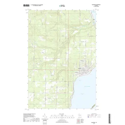
2018 Map of Washburn
USGS Topo · Published 2018About this map
Washburn sits along the western shoreline of Chequamegon Bay, serving as a central hub for this coastal portion of Bayfield County. The landscape is defined by the transition from the upland woods of the Little Sioux River and Sioux River drainage basins down to the intricate wetlands of the Sioux River Slough on Lake Superior. The town's grid is well-established, stretching toward the water at Vandeventer Bay with local landmarks like Woodlawn Cem and Calvary Cem situated on the north side of the settlement. To the north, the small community of Sioux marks the mouth of its namesake river. The area is intersected by numerous named rural routes such as Friendly Valley Rd and Kjarvick Rd, reflecting the scattered residential and agricultural footprint that fans out from the lakefront into the timbered interior.
Find a feature on this map
85 named features on this map. Tap any name to fly to it.
Don’t see what you’re looking for? This feature index may not catch every label — zoom into the map to look around manually.
Map Details
Editions of this 2018 Washburn Map
This is the sole edition of this map. No revisions or reprints were ever made.
Other maps of this area

1941 · Bayfield
USGS Topo · 1:48,000

1942 · Ashland
USGS Topo · 1:48,000

1944 · Moquah
USGS Topo · 1:48,000

1944 · Cornucopia
USGS Topo · 1:48,000

1946 · Cornucopia
USGS Topo · 1:48,000

1946 · Bayfield
USGS Topo · 1:48,000

1947 · Moquah
USGS Topo · 1:48,000

1947 · Ashland
USGS Topo · 1:48,000

1953 · Ashland
USGS Topo · 1:250,000

1958 · Ashland
USGS Topo · 1:250,000