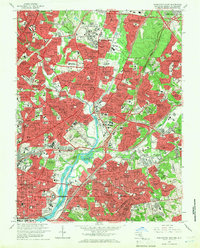
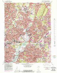
1965 Map of Washington East
USGS Topo · Published 1966About this map
The Anacostia River and its major tributaries, the Northwest Branch and Northeast Branch, anchor this mid-1960s study of the Maryland-District of Columbia border. The landscape shows a densely settled corridor of communities stretching from Hyattsville and College Park toward the capital, where suburban growth is visible in neighborhoods like New Carrollton and Kent Village. This era captures a balance of urban infrastructure and significant green space, featuring the sprawling grounds of the University of Maryland, the National Arboretum, and the Kenilworth Aquatic Gardens. The transportation network is defined by the Baltimore Washington Parkway, the Pennsylvania Railroad, and the Baltimore and Ohio Railroad, illustrating how rail and highway connectivity fueled the region's development. Civil defense and local history are marked by the presence of numerous neighborhood schools, hospitals like Providence Hospital, and historic burial grounds including Fort Lincoln Cemetery and Congressional Cemetery.
Find a feature on this map
169 named features on this map. Tap any name to fly to it.
Don’t see what you’re looking for? This feature index may not catch every label — zoom into the map to look around manually.
Map Details
Editions of this 1965 Washington East Map
5 editions found
Other maps of this area

1890 · Mt. Vernon
USGS Topo · 1:125,000

1891 · Mt. Vernon
USGS Topo · 1:125,000

1892 · Laurel
USGS Topo · 1:62,500

1893 · Frederick
USGS Topo · 1:125,000

1894 · Laurel
USGS Topo · 1:62,500

1894 · Frederick
USGS Topo · 1:125,000

1894 · Mt. Vernon
USGS Topo · 1:125,000

1897 · Laurel
USGS Topo · 1:62,500

1897 · Mt. Vernon
USGS Topo · 1:125,000

1899 · Patuxent
USGS Topo · 1:125,000