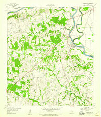
1958 Map of Washington
USGS Topo · Published 1960About this map
Hidalgo Bluffs overlook the winding course of the Brazos River in this 1958 survey, where the river serves as a primary boundary between Washington, Brazos, and Grimes Counties. The landscape is defined by the confluence of the Brazos and the Navasota River, a significant hydrological junction for the region. Historical settlement patterns are evident in the concentration of rural institutions, such as St Matthew Ch and its accompanying St Matthew Sch, alongside Friedens Ch and Mt Zion Sch. These sites, along with the Washington State Park grounds, mark the area's significance as a cradle of Texas history. The map also records mid-century land use through several Quarry and Gravel Pit operations, while the small community of Graball sits to the southeast near the upper reaches of Rocky Creek.
Find a feature on this map
24 named features on this map. Tap any name to fly to it.
Don’t see what you’re looking for? This feature index may not catch every label — zoom into the map to look around manually.
Map Details
Editions of this 1958 Washington Map
3 editions found
Other maps of this area

1913 · Millican
USGS Topo · 1:31,680

1914 · Gay Hill
USGS Topo · 1:62,500

1914 · Navasota
USGS Topo · 1:62,500

1930 · Brenham
USGS Topo · 1:62,500

1954 · Austin
USGS Topo · 1:250,000

1956 · Hempstead
USGS Topo · 1:62,500

1956 · Brenham
USGS Topo · 1:62,500

1958 · Washington
USGS Topo · 1:24,000

1958 · Navasota
USGS Topo · 1:24,000

1958 · Courtney
USGS Topo · 1:24,000