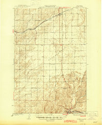
1925 Map of Washtucna
USGS Topo · Published 1945About this map
Washtucna serves as the southern anchor of this Adams County landscape, surveyed in the early 1920s when the region was defined by a critical intersection of rail lines and rural school districts. The Spokane Portland and Seattle railroad passes through the south, while the Chicago Milwaukee St. Paul and Pacific cuts across the northern reaches, supporting small settlements like Ralston and Pizarro.
Find a feature on this map
22 named features on this map. Tap any name to fly to it.
Don’t see what you’re looking for? This feature index may not catch every label — zoom into the map to look around manually.
Map Details
Editions of this 1925 Washtucna Map
2 editions found
Other maps of this area

1916 · Connell
USGS Topo · 1:125,000

1918 · Connell
USGS Topo · 1:125,000

1923 · Washtucna
USGS Topo · 1:62,500

1925 · Washtucna
USGS Topo · 1:62,500

1948 · Starbuck
USGS Topo · 1:62,500

1948 · Ayer
USGS Topo · 1:62,500

1950 · Starbuck
USGS Topo · 1:62,500

1950 · Haas
USGS Topo · 1:62,500

1950 · Benge
USGS Topo · 1:62,500

1952 · Benge
USGS Topo · 1:62,500