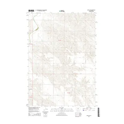
2015 Map of Wasta NE
USGS Topo · Published 2015About this map
The Cheyenne River carves a winding path along the western edge of this South Dakota landscape, marking a clear physical and jurisdictional boundary between Meade Co and Pennington Co. This 2015 survey reveals a land defined by its drainages, where a network of seasonal watercourses including Elk Cr, Cow Cr, and Bull Cr have etched deep into the plains. The terrain transitions from the high, level plateau of Cow Flat down through dramatic incisions like Seventysix Draw, illustrating the erosional power that defines this portion of the Great Plains. The human presence is mapped through a sparse but functional grid of rural routes such as Trask Rd and Pascoe Rd, which follow the township and range lines established by the Public Land Survey System. These roads provide access to the vast interior sections of t3n r15e and t2n r15e, supporting the ranching and agricultural activities traditional to the region.
Find a feature on this map
18 named features on this map. Tap any name to fly to it.
Don’t see what you’re looking for? This feature index may not catch every label — zoom into the map to look around manually.
Map Details
Editions of this 2015 Wasta NE Map
This is the sole edition of this map. No revisions or reprints were ever made.
Other maps of this area

1953 · Rapid City
USGS Topo · 1:250,000

1954 · Dalzell SE
USGS Topo · 1:24,000

1954 · Wasta NE
USGS Topo · 1:24,000

1954 · Wasta SE
USGS Topo · 1:24,000

1954 · Dalzell
USGS Topo · 1:24,000

1954 · Wasta
USGS Topo · 1:24,000

1954 · Wasta NW
USGS Topo · 1:24,000

1955 · Creighton
USGS Topo · 1:24,000

1957 · Rapid City
USGS Topo · 1:250,000
1983 · Lake Hill
USGS Topo · 1:24,000