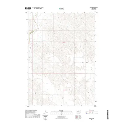
2017 Map of Wasta NE
USGS Topo · Published 2017About this map
The Cheyenne River winds through the northwestern corner of this landscape, defining the boundary between Meade and Pennington counties. This rugged river valley is joined by Elk Cr as it carves through the terrain, contrasting with the higher, flatter plateaus to the south and east. The map illustrates a sparse rural transport network characteristic of the West River region, anchored by gravel and dirt routes like Trask Rd and Pascoe Rd. Significant local landforms include the broad expanse of Cow Flat and the drainage of Seventysix Draw in the southwest. These features, along with several creek systems including Cow Cr and Bull Cr, reveal a landscape shaped by intermittent water flow and cattle ranching traditions in a remote part of South Dakota.
Find a feature on this map
16 named features on this map. Tap any name to fly to it.
Don’t see what you’re looking for? This feature index may not catch every label — zoom into the map to look around manually.
Map Details
Editions of this 2017 Wasta NE Map
This is the sole edition of this map. No revisions or reprints were ever made.
Other maps of this area

1953 · Rapid City
USGS Topo · 1:250,000

1954 · Dalzell SE
USGS Topo · 1:24,000

1954 · Wasta NE
USGS Topo · 1:24,000

1954 · Wasta SE
USGS Topo · 1:24,000

1954 · Dalzell
USGS Topo · 1:24,000

1954 · Wasta
USGS Topo · 1:24,000

1954 · Wasta NW
USGS Topo · 1:24,000

1955 · Creighton
USGS Topo · 1:24,000

1957 · Rapid City
USGS Topo · 1:250,000
1983 · Lake Hill
USGS Topo · 1:24,000