
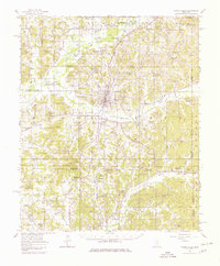
1954 Map of Water Valley
USGS Topo · Published 1966About this map
Water Valley sits at the heart of this landscape, where the Illinois Central railroad and Otoucalofa Creek intersect. The terrain is marked by the vast reach of the Enid Reservoir to the northwest, with its conservation pool and spillway heights meticulously noted. Away from the town center, the map reveals a dense network of rural community hubs, such as Pine Valley and Velma, defined more by their social institutions than commercial density.
Find a feature on this map
125 named features on this map. Tap any name to fly to it.
Don’t see what you’re looking for? This feature index may not catch every label — zoom into the map to look around manually.
Map Details
Editions of this 1954 Water Valley Map
2 editions found
Other maps of this area

1940 · Oxford
USGS Topo · 1:62,500

1942 · Denmark
USGS Topo · 1:62,500

1943 · Denmark
USGS Topo · 1:62,500

1943 · Oxford
USGS Topo · 1:62,500

1952 · Sardis
USGS Topo · 1:62,500

1953 · Sardis
USGS Topo · 1:62,500

1953 · West Point
USGS Topo · 1:250,000

1954 · Pittsboro
USGS Topo · 1:62,500

1954 · Grenada
USGS Topo · 1:62,500

1954 · Oakland
USGS Topo · 1:62,500