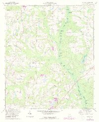
1973 Map of Waterloo
USGS Topo · Published 1987About this map
The Alapaha River corridor dominates this 1970s landscape, winding through a complex network of wetlands and oxbow lakes on the boundary of Irwin and Tift counties. This riverine environment is dotted with numerous small water bodies, many bearing local descriptive names like Horse Ford Lake, Mudcat Lake, and the recurring Graveyard Lake. Settlement is sparse, focused around the community of Waterloo and the smaller gathering point at Harding, which sits near an Old Railroad Grade that speaks to former transportation routes through the coastal plain.
Find a feature on this map
42 named features on this map. Tap any name to fly to it.
Don’t see what you’re looking for? This feature index may not catch every label — zoom into the map to look around manually.
Map Details
Editions of this 1973 Waterloo Map
2 editions found
Other maps of this area

1953 · Waycross
USGS Topo · 1:250,000

1958 · Waycross
USGS Topo · 1:250,000

1973 · Ocilla West
USGS Topo · 1:24,000

1973 · Waterloo
USGS Topo · 1:24,000

1973 · Irwinville
USGS Topo · 1:24,000

1973 · Enigma
USGS Topo · 1:24,000

1973 · Chula
USGS Topo · 1:24,000

1973 · Tifton East
USGS Topo · 1:24,000

1973 · Tifton West
USGS Topo · 1:24,000

1973 · Bethel
USGS Topo · 1:24,000