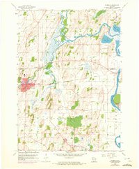
1959 Map of Waterloo
USGS Topo · Published 1972About this map
The Crawfish River meanders through the central and eastern portions of this Jefferson County landscape, shaping the development of Waterloo and the surrounding rural townships. During the mid-20th century, this area remained deeply tied to its agricultural roots and rail-based commerce, with the Chicago Milwaukee St Paul and Pacific railroad providing a vital corridor through Hubbleton and the city center. The map reveals a high density of community landmarks, including St John Sch and several remote burial grounds such as Washington Cem and South Road Cem.
Find a feature on this map
32 named features on this map. Tap any name to fly to it.
Don’t see what you’re looking for? This feature index may not catch every label — zoom into the map to look around manually.
Map Details
Editions of this 1959 Waterloo Map
3 editions found
Other maps of this area

1890 · Sun Prairie
USGS Topo · 1:62,500

1891 · Waterloo
USGS Topo · 1:62,500

1894 · Waterloo
USGS Topo · 1:62,500

1896 · Sun Prairie
USGS Topo · 1:62,500

1905 · Sun Prairie
USGS Topo · 1:62,500

1907 · Sun Prairie
USGS Topo · 1:62,500

1910 · Waterloo
USGS Topo · 1:62,500

1955 · Columbus
USGS Topo · 1:62,500

1955 · Beaver Dam
USGS Topo · 1:62,500

1957 · Madison
USGS Topo · 1:250,000