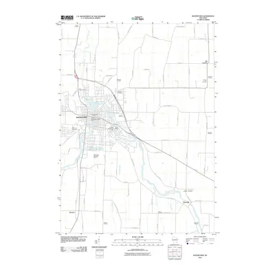
2010 Map of Watertown
USGS Topo · Published 2010About this map
The Rock River winds through the heart of Watertown, defining the geography of this southern Wisconsin landscape. This 2010 survey shows the river's significant infrastructure, including the Lower Watertown Dam and Upper Watertown Dam, which historically powered the region's development. The map details a dense network of local roads and county highways connecting Watertown to outlying rural settlements like Old Lebanon, Pipersville, and Ebenezer.
Find a feature on this map
72 named features on this map. Tap any name to fly to it.
Don’t see what you’re looking for? This feature index may not catch every label — zoom into the map to look around manually.
Map Details
Editions of this 2010 Watertown Map
This is the sole edition of this map. No revisions or reprints were ever made.
Other maps of this area

1891 · Waterloo
USGS Topo · 1:62,500

1892 · Watertown
USGS Topo · 1:62,500

1894 · Waterloo
USGS Topo · 1:62,500

1894 · Watertown
USGS Topo · 1:62,500

1910 · Waterloo
USGS Topo · 1:62,500

1955 · Beaver Dam
USGS Topo · 1:62,500

1955 · Horicon
USGS Topo · 1:62,500

1957 · Madison
USGS Topo · 1:250,000
1959 · Richwood
USGS Topo · 1:24,000
1959 · Helenville
USGS Topo · 1:24,000