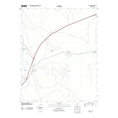
2010 Map of Watrous
USGS Topo · Published 2010About this map
The Mora River and its complex network of irrigation ditches anchor this northern New Mexico landscape, where the Santa Fe Trl remains a visible legacy of historic transit. At the confluence of the Sapello River and the Mora, the settlement of Watrous serves as a local hub, featuring the Watrous Post Office. To the north, Tiptonville and the Tiptonville Cemetery reflect earlier stages of rural community development. A distinct medical and social history is preserved at the Valmora Sanatorium Historic District near Valmora, while the surrounding terrain is managed through engineered water features like the Middle Clyde Ditch, Lower Phoenix Ditch, and Tipton Ditch. This 2010 topographic record captures a high-desert environment defined by ranching landmarks such as Sellman Brothers and the Doolittle Ranch Airport, set against the geological backdrop of Boone Valley and various seasonal arroyos.
Find a feature on this map
24 named features on this map. Tap any name to fly to it.
Don’t see what you’re looking for? This feature index may not catch every label — zoom into the map to look around manually.
Map Details
Editions of this 2010 Watrous Map
This is the sole edition of this map. No revisions or reprints were ever made.
Other maps of this area

1889 · Las Vegas
USGS Topo · 1:125,000

1891 · Las Vegas
USGS Topo · 1:125,000

1892 · Watrous
USGS Topo · 1:125,000

1893 · Las Vegas
USGS Topo · 1:125,000

1894 · Watrous
USGS Topo · 1:125,000

1954 · Santa Fe
USGS Topo · 1:250,000

1958 · Santa Fe
USGS Topo · 1:250,000

1963 · Fort Union
USGS Topo · 1:24,000
1963 · Loma Parda
USGS Topo · 1:24,000
1963 · Onava
USGS Topo · 1:24,000