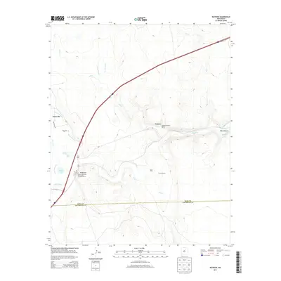
2013 Map of Watrous
USGS Topo · Published 2013About this map
The Mora River and Sapello River confluence defines the irrigation and settlement patterns of this section of northern New Mexico. The small community of Watrous serves as a central point, situated near a network of historic water management features including the Tipton Ditch and several Clyde and Phoenix ditches. This 2013 record highlights significant cultural landmarks such as the Valmora Sanatorium Historic District and the William Kroenig Hay Barns Number 51 and Number 52, illustrating the area's agricultural and institutional heritage.
Find a feature on this map
29 named features on this map. Tap any name to fly to it.
Don’t see what you’re looking for? This feature index may not catch every label — zoom into the map to look around manually.
Map Details
Editions of this 2013 Watrous Map
This is the sole edition of this map. No revisions or reprints were ever made.
Other maps of this area

1889 · Las Vegas
USGS Topo · 1:125,000

1891 · Las Vegas
USGS Topo · 1:125,000

1892 · Watrous
USGS Topo · 1:125,000

1893 · Las Vegas
USGS Topo · 1:125,000

1894 · Watrous
USGS Topo · 1:125,000

1954 · Santa Fe
USGS Topo · 1:250,000

1958 · Santa Fe
USGS Topo · 1:250,000

1963 · Fort Union
USGS Topo · 1:24,000
1963 · Loma Parda
USGS Topo · 1:24,000
1963 · Onava
USGS Topo · 1:24,000