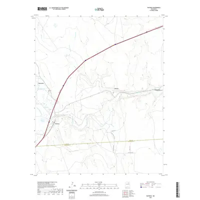
2020 Map of Watrous
USGS Topo · Published 2020About this map
The confluence of the Sapello River and the Mora River defines the landscape of this New Mexico quadrangle, where the historic path of the Santa Fe Trl remains a primary corridor for transportation and settlement. The small community of Watrous sits near this junction, surrounded by an intricate system of agricultural irrigation canals like the Tipton Ditch, Middle Clyde Ditch, and Lower Phoenix Ditch. These waterways support local life and ranching along the valley floor, connecting several distinct settlements including Tiptonville, Valmora, and Shoemaker.
Find a feature on this map
27 named features on this map. Tap any name to fly to it.
Don’t see what you’re looking for? This feature index may not catch every label — zoom into the map to look around manually.
Map Details
Editions of this 2020 Watrous Map
This is the sole edition of this map. No revisions or reprints were ever made.
Other maps of this area

1889 · Las Vegas
USGS Topo · 1:125,000

1891 · Las Vegas
USGS Topo · 1:125,000

1892 · Watrous
USGS Topo · 1:125,000

1893 · Las Vegas
USGS Topo · 1:125,000

1894 · Watrous
USGS Topo · 1:125,000

1954 · Santa Fe
USGS Topo · 1:250,000

1958 · Santa Fe
USGS Topo · 1:250,000

1963 · Fort Union
USGS Topo · 1:24,000
1963 · Loma Parda
USGS Topo · 1:24,000
1963 · Onava
USGS Topo · 1:24,000