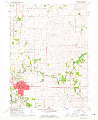
1964 Map of Watseka
USGS Topo · Published 1965About this map
The confluence of the Iroquois River and Sugar Creek defines the local geography of this 1960s Iroquois County landscape. Watseka serves as the central hub, showing its residential expansion and civic infrastructure, including the Courthouse, Iroquois Hospital, and High School. The city is a crossroads for heavy rail, where the Chicago and Eastern Illinois intersects with the Toledo Peoria and Western line.
Find a feature on this map
36 named features on this map. Tap any name to fly to it.
Don’t see what you’re looking for? This feature index may not catch every label — zoom into the map to look around manually.
Map Details
Editions of this 1964 Watseka Map
This is the sole edition of this map. No revisions or reprints were ever made.
Other maps of this area

1935 · Watseka
USGS Topo · 1:48,000

1938 · Milford
USGS Topo · 1:48,000

1939 · Watseka
USGS Topo · 1:62,500

1939 · Cissna Park
USGS Topo · 1:62,500

1944 · Milford
USGS Topo · 1:62,500

1944 · Gilman
USGS Topo · 1:62,500

1946 · Gilman
USGS Topo · 1:62,500

1949 · Cissna Park
USGS Topo · 1:62,500

1953 · Danville
USGS Topo · 1:250,000

1955 · Danville
USGS Topo · 1:250,000