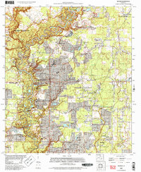
2005 Map of Watson
USGS Topo · Published 2006About this map
The Amite River carves a winding path through this portion of Livingston Parish and East Baton Rouge Parish, defining a landscape where rural crossroads meet modern expansion. The community of Watson serves as a central hub, surrounded by a dense network of local institutions like Live Oak Church and Live Oak High School. To the west, the historic character of Greenwell Springs and the residential clusters at Bellingrath Hills and Evergreen Hills illustrate the transition from agricultural land to established suburban settlements. The presence of the Watson Oil Field and Fish Field points to the region's underlying industrial economy, while numerous small family and church burial grounds, including the New Bethlehem and Womack Cemetery sites, provide valuable touchpoints for genealogical research. Distinctive landmarks such as the Indian Mound and the Country Bend Airport further distinguish this corner of the Louisiana river parishes.
Find a feature on this map
56 named features on this map. Tap any name to fly to it.
Don’t see what you’re looking for? This feature index may not catch every label — zoom into the map to look around manually.
Map Details
Editions of this 2005 Watson Map
This is the sole edition of this map. No revisions or reprints were ever made.
Other maps of this area

1906 · Bayou Sara
USGS Topo · 1:125,000

1908 · Baton Rouge
USGS Topo · 1:62,500

1934 · Denham Springs
USGS Topo · 1:62,500

1939 · Zachary
USGS Topo · 1:62,500

1939 · Denham Springs
USGS Topo · 1:62,500

1939 · Baton Rouge
USGS Topo · 1:62,500

1942 · Pine Grove
USGS Topo · 1:31,680

1942 · Pride
USGS Topo · 1:31,680

1942 · Watson
USGS Topo · 1:31,680

1942 · Satsuma
USGS Topo · 1:31,680