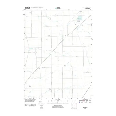
2010 Map of Watson
USGS Topo · Published 2010About this map
Lowell and the small settlement of Watson anchor this rural Ohio landscape, defined by a dense network of township and county roads that follow the state's characteristic rectangular survey grid. The region is heavily marked by its genealogical significance, featuring numerous family and community burial grounds such as Raymond Cemetery, Bunker Hill Cemetery, and Egbert Cemetery. In the northeastern corner, the Beaver Creek Upground Reservoir and its associated Beaver Creek Upground Reservoir Dam represent modern water management infrastructure along the meandering path of Beaver Creek. The drainage patterns of the area are complex, with several distinct waterways including Sugar Creek, Indian Creek, and Spicer Creek cutting through the farmland. Local recreation and aviation are also noted, with the Clinton Heights Golf Course located in the southwest and the Weiker Airport situated near the reservoir.
Find a feature on this map
58 named features on this map. Tap any name to fly to it.
Don’t see what you’re looking for? This feature index may not catch every label — zoom into the map to look around manually.
Map Details
Editions of this 2010 Watson Map
This is the sole edition of this map. No revisions or reprints were ever made.
Other maps of this area

1901 · Bellevue
USGS Topo · 1:62,500

1901 · Fremont
USGS Topo · 1:62,500

1903 · Bellevue
USGS Topo · 1:62,500

1903 · Fremont
USGS Topo · 1:62,500

1906 · Tiffin
USGS Topo · 1:62,500

1915 · Siam
USGS Topo · 1:62,500

1956 · Toledo
USGS Topo · 1:250,000

1958 · Fremont West
USGS Topo · 1:24,000
1958 · Fremont East
USGS Topo · 1:24,000
1959 · Clyde
USGS Topo · 1:24,000