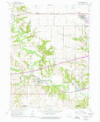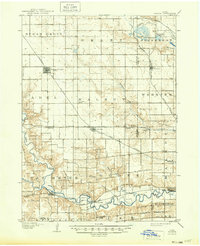
1908 Map of Waukee
USGS Topo · Published 1949About this map
Waukee and the surrounding townships of Dallas and Polk counties appear here at a pivotal moment of agricultural and industrial expansion during the early twentieth century. The landscape is defined by a dense grid of section lines and the convergent paths of major railroads, including the Chicago Milwaukee and St. Paul RR and the Minneapolis and St. Louis RR. These steel arteries linked growing trade centers like Dallas Center and Grimes to the broader regional economy, while small rural education hubs like Valley Grove School and Pleasant Plain School served the farming families of Walnut and Grant townships.
Find a feature on this map
37 named features on this map. Tap any name to fly to it.
Don’t see what you’re looking for? This feature index may not catch every label — zoom into the map to look around manually.
Map Details
Editions of this 1908 Waukee Map
2 editions found

Historical Maps of West Des Moines Through Time
7 maps found