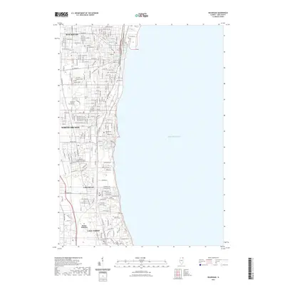
2021 Map of Waukegan
USGS Topo · Published 2021About this map
The industrialized shoreline of Lake Michigan dominates this modern landscape, tracing the urban corridor from Waukegan south through North Chicago and Lake Forest. This area is defined by its deep institutional and maritime roots, anchored by the Waukegan Harbor and the Waukegan River. The presence of major educational centers like Lake Forest College, the College of Lake County, and Rosalind Franklin University of Medicine and Science highlights the region's development as a hub for higher education and healthcare research.
Find a feature on this map
76 named features on this map. Tap any name to fly to it.
Don’t see what you’re looking for? This feature index may not catch every label — zoom into the map to look around manually.
Map Details
Editions of this 2021 Waukegan Map
This is the sole edition of this map. No revisions or reprints were ever made.
Other maps of this area

1899 · Evanston
USGS Topo · 1:62,500

1900 · Highwood
USGS Topo · 1:62,500

1906 · Waukegan
USGS Topo · 1:62,500

1908 · Waukegan
USGS Topo · 1:62,500

1928 · Wheeling
USGS Topo · 1:24,000

1928 · Highland Park
USGS Topo · 1:24,000

1951 · Highland Park
USGS Topo · 1:24,000
1953 · Highland Park
USGS Topo · 1:24,000
1953 · Wheeling
USGS Topo · 1:24,000

1958 · Racine
USGS Topo · 1:250,000