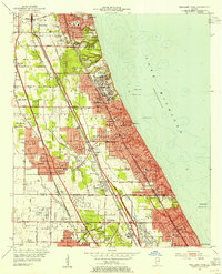
1953 Map of Highland Park
USGS Topo · Published 1955About this map
Fort Sheridan and its military reservation dominate the Lake Michigan shoreline in this mid-century survey of Chicago’s North Shore suburbs. The landscape is characterized by a dense concentration of early twentieth-century leisure and educational institutions, including the Onwentsia Club, Exmoor Country Club, and Lake Forest Academy. Inland, the terrain is defined by the three branches of the Chicago River, where developing residential communities like Deerfield and Bannockburn began to fill the spaces between established rail lines.
Find a feature on this map
68 named features on this map. Tap any name to fly to it.
Don’t see what you’re looking for? This feature index may not catch every label — zoom into the map to look around manually.
Map Details
Editions of this 1953 Highland Park Map
This is the sole edition of this map. No revisions or reprints were ever made.
Other maps of this area

1899 · Evanston
USGS Topo · 1:62,500

1900 · Highwood
USGS Topo · 1:62,500

1906 · Waukegan
USGS Topo · 1:62,500

1908 · Waukegan
USGS Topo · 1:62,500

1927 · Arlington Heights
USGS Topo · 1:24,000

1928 · Wheeling
USGS Topo · 1:24,000

1928 · Highland Park
USGS Topo · 1:24,000

1928 · Evanston
USGS Topo · 1:24,000

1929 · Park Ridge
USGS Topo · 1:24,000

1951 · Highland Park
USGS Topo · 1:24,000