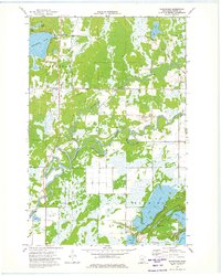
1973 Map of Waukenabo
USGS Topo · Published 1975About this map
The Mississippi River winds through the heart of this Aitkin County landscape, accompanied by a complex system of oxbows such as White Elk Logan and Clark Logan. These river features, locally termed "logans," illustrate the shifting hydrology of the northern Minnesota wetlands during the early 1970s. The settlement of Waukenabo serves as a small focal point near the northern shore of Waukenabo Lake, featuring the Townhall and the Waukenabo Cem. To the east, the Soo Line railroad cuts a straight path through the township of Logan, passing by the Pine Grove Cem. In the southern portion of the map, the terrain is dominated by significant water bodies including Gun Lake, Wilkins Lake, and Fleming Lake. Local infrastructure of the era is represented by a Landing Strip near the Gun Lake shore and a Fish Hatchery located further west near Sutton.
Find a feature on this map
37 named features on this map. Tap any name to fly to it.
Don’t see what you’re looking for? This feature index may not catch every label — zoom into the map to look around manually.
Map Details
Editions of this 1973 Waukenabo Map
This is the sole edition of this map. No revisions or reprints were ever made.
Other maps of this area

1914 · Aitkin
USGS Topo · 1:62,500

1915 · Aitkin
USGS Topo · 1:62,500

1953 · Duluth
USGS Topo · 1:250,000

1958 · Duluth
USGS Topo · 1:250,000

1970 · Kimberly
USGS Topo · 1:24,000

1970 · Palisade
USGS Topo · 1:24,000

1970 · Sanders Lake
USGS Topo · 1:24,000

1970 · Bain
USGS Topo · 1:24,000

1970 · White Elk Lake
USGS Topo · 1:24,000
1973 · Hassman
USGS Topo · 1:24,000