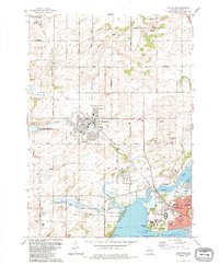
1983 Map of Waunakee
USGS Topo · Published 1984About this map
Lake Mendota defines the southern edge of this 1980s landscape, where the northern expansion of Madison meets the agricultural townships of Westport and Vienna. The terrain is marked by significant state and county institutions, including the expansive grounds of the Mendota State Hospital and the Central Wisconsin Training School near Farwells Point. This era shows a community in transition, balancing protected natural spaces like the Waunakee Marsh State Wildlife Management Area and the Dorn Creek Marsh State Fishery Area with emerging residential subdivisions and the active Chicago and North Western rail line. The village of Waunakee serves as a central hub, flanked by its High School and the Waunakee Landing Field. Rural identity remains visible in the numerous family-named gravel pits and the scattered country schools like Norway Grove School that once anchored the outlying crossroads.
Find a feature on this map
63 named features on this map. Tap any name to fly to it.
Don’t see what you’re looking for? This feature index may not catch every label — zoom into the map to look around manually.
Map Details
Editions of this 1983 Waunakee Map
This is the sole edition of this map. No revisions or reprints were ever made.
Other maps of this area

1890 · Madison
USGS Topo · 1:62,500

1892 · Madison
USGS Topo · 1:62,500

1895 · Baraboo
USGS Topo · 1:62,500

1901 · Poynette
USGS Topo · 1:62,500

1904 · Madison
USGS Topo · 1:62,500

1906 · Madison
USGS Topo · 1:62,500

1907 · Cross Plains
USGS Topo · 1:62,500

1908 · Baraboo
USGS Topo · 1:62,500

1909 · Cross Plains
USGS Topo · 1:62,500

1957 · Madison
USGS Topo · 1:250,000