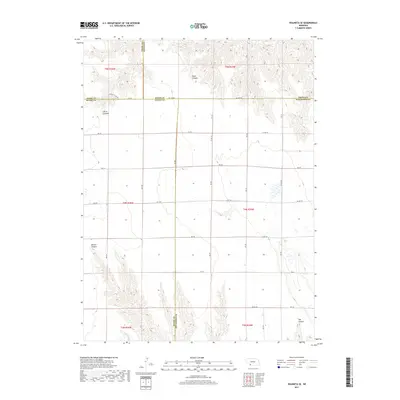
2017 Map of Wauneta SE
USGS Topo · Published 2017About this map
E Muddy Cr winds through the southwestern corner of this landscape, where the High Plains terrain is carved by a series of distinct drainage features. The area is defined by its dramatic topographic relief, including Sand Canyon in the north and the deep indentations of Horse Canyon, Milken Canyon, and Hay Canyon. This 2017 survey reveals the strictly organized section-line road grid that overlays the natural drainage patterns, with Chase Co Line Rd and Co Line Rd marking the political boundaries of Chase, Hayes, Dundy, and Hitchcock counties. The map serves as a detailed record of the intersection of these four Nebraska counties, illustrating how modern agriculture and rural infrastructure, represented by routes like 8th Ave, adapt to the broken canyon country that disrupts the otherwise flat agricultural plateau.
Find a feature on this map
38 named features on this map. Tap any name to fly to it.
Don’t see what you’re looking for? This feature index may not catch every label — zoom into the map to look around manually.
Map Details
Editions of this 2017 Wauneta SE Map
This is the sole edition of this map. No revisions or reprints were ever made.
Other maps of this area

1954 · McCook
USGS Topo · 1:250,000

1957 · McCook
USGS Topo · 1:250,000

1958 · McCook
USGS Topo · 1:250,000

1962 · Stratton
USGS Topo · 1:24,000

1962 · Max NE
USGS Topo · 1:24,000

1973 · Wauneta SW
USGS Topo · 1:24,000
1973 · Rock Canyon
USGS Topo · 1:24,000

1973 · Palisade SW
USGS Topo · 1:24,000

1973 · Wauneta SE
USGS Topo · 1:24,000

1974 · Hamlet
USGS Topo · 1:24,000