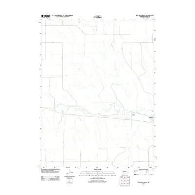
2011 Map of Wauneta West
USGS Topo · Published 2011About this map
Frenchman Creek meanders through the heart of this High Plains landscape, marking the primary topographical feature in an area otherwise defined by the systematic grid of rural roads. To the east, the edge of Wauneta appears along the valley floor, where the confluence of local routes like W Wichita St and Old 6 meet the township boundaries. The presence of Riverside Cemetery overlooking the creek valley provides a specific point of interest for genealogists tracing Chase County roots. The map illustrates the 2011 transition from traditional named highways to the numbered section-line system, such as 342 Ave and 735 Rd, which facilitate the region's agricultural transport. This survey reflects the enduring spatial organization of Nebraska's farming communities, where settlement patterns remain closely tied to the available water of the creek corridor.
Find a feature on this map
17 named features on this map. Tap any name to fly to it.
Don’t see what you’re looking for? This feature index may not catch every label — zoom into the map to look around manually.
Map Details
Editions of this 2011 Wauneta West Map
This is the sole edition of this map. No revisions or reprints were ever made.
Other maps of this area

1954 · McCook
USGS Topo · 1:250,000

1957 · McCook
USGS Topo · 1:250,000

1958 · McCook
USGS Topo · 1:250,000

1973 · Enders
USGS Topo · 1:24,000

1973 · Ough
USGS Topo · 1:24,000

1973 · Wauneta SW
USGS Topo · 1:24,000

1973 · Wauneta SE
USGS Topo · 1:24,000

1973 · Imperial Municipal Airport
USGS Topo · 1:24,000

1974 · Dittons Creek SE
USGS Topo · 1:24,000
1974 · Wauneta West
USGS Topo · 1:24,000