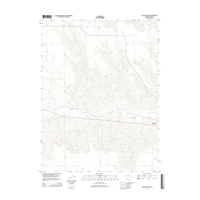
2014 Map of Wauneta West
USGS Topo · Published 2014About this map
Frenchman Cr carves a distinct path through this section of Southwest Nebraska, defining the layout of the small community of Wauneta. This 2014 survey illustrates the junction of rural section roads and the enduring corridor of Old 6, which navigates the high tableland before dropping toward the creek valley. The topography is marked by significant drainage patterns feeding into the Frenchman valley, creating a series of ridges and draws that dictate the local road network, including 736 Rd and 735 Rd. Genealogists and local historians will find the exact location of Riverside Cem on the northwestern outskirts of town, situated near the transition from residential streets like Wichita St to the open agricultural plains. The map reflects a landscape where modern infrastructure aligns with traditional land divisions and the vital water source of the creek.
Find a feature on this map
16 named features on this map. Tap any name to fly to it.
Don’t see what you’re looking for? This feature index may not catch every label — zoom into the map to look around manually.
Map Details
Editions of this 2014 Wauneta West Map
This is the sole edition of this map. No revisions or reprints were ever made.
Other maps of this area

1954 · McCook
USGS Topo · 1:250,000

1957 · McCook
USGS Topo · 1:250,000

1958 · McCook
USGS Topo · 1:250,000

1973 · Enders
USGS Topo · 1:24,000

1973 · Ough
USGS Topo · 1:24,000

1973 · Wauneta SW
USGS Topo · 1:24,000

1973 · Wauneta SE
USGS Topo · 1:24,000

1973 · Imperial Municipal Airport
USGS Topo · 1:24,000

1974 · Dittons Creek SE
USGS Topo · 1:24,000
1974 · Wauneta West
USGS Topo · 1:24,000