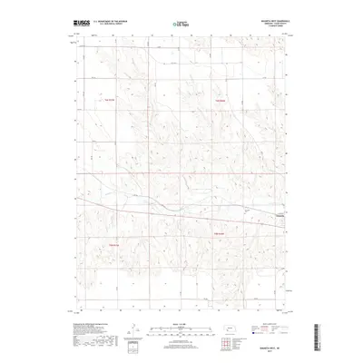
2017 Map of Wauneta West
USGS Topo · Published 2017About this map
Frenchman Cr meanders across the center of this Chase County landscape, providing the primary drainage for the agricultural tablelands of Southwest Nebraska. The settlement of Wauneta occupies the eastern edge of the quadrangle, where the street grid transitions from W Wichita St into a network of section-line rural roads including Old Hwy 6 and 344 Ave. The land is defined by the Public Land Survey System, with township boundaries for t6n r37w, t6n r36w, t5n r37w, and t5n r36w marking the organized agricultural heritage of the region. Local history is anchored at the Riverside Cem, situated just west of the town center above the creek valley. The map reveals the precise intersection of topography and human infrastructure, showing how irrigation and elevation contours influence the placement of thoroughfares like Rd 730 and 342 Ave.
Find a feature on this map
26 named features on this map. Tap any name to fly to it.
Don’t see what you’re looking for? This feature index may not catch every label — zoom into the map to look around manually.
Map Details
Editions of this 2017 Wauneta West Map
This is the sole edition of this map. No revisions or reprints were ever made.
Other maps of this area

1954 · McCook
USGS Topo · 1:250,000

1957 · McCook
USGS Topo · 1:250,000

1958 · McCook
USGS Topo · 1:250,000

1973 · Enders
USGS Topo · 1:24,000

1973 · Ough
USGS Topo · 1:24,000

1973 · Wauneta SW
USGS Topo · 1:24,000

1973 · Wauneta SE
USGS Topo · 1:24,000

1973 · Imperial Municipal Airport
USGS Topo · 1:24,000

1974 · Dittons Creek SE
USGS Topo · 1:24,000
1974 · Wauneta West
USGS Topo · 1:24,000