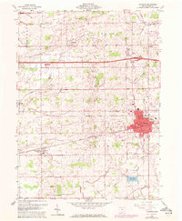
1960 Map of Wauseon
USGS Topo · Published 1972About this map
Wauseon serves as the focal point of this Northwest Ohio landscape, shown during a period of transition as mid-century infrastructure met established agricultural patterns. The town's grid is anchored by the Penn Central and Norfolk and Western rail lines, which intersect near the center of the community. To the north, the Ohio Turnpike cuts a straight eastward path across Fulton Line, marking the modernization of travel through the county.
Find a feature on this map
42 named features on this map. Tap any name to fly to it.
Don’t see what you’re looking for? This feature index may not catch every label — zoom into the map to look around manually.
Map Details
Editions of this 1960 Wauseon Map
3 editions found
Other maps of this area

1907 · Defiance
USGS Topo · 1:62,500

1908 · Napoleon
USGS Topo · 1:62,500

1909 · Defiance
USGS Topo · 1:62,500

1911 · Wauseon
USGS Topo · 1:62,500

1913 · Wauseon
USGS Topo · 1:62,500

1913 · Alvordton
USGS Topo · 1:62,500

1943 · Wauseon
USGS Topo · 1:62,500

1944 · Alvordton
USGS Topo · 1:62,500

1953 · Fort Wayne
USGS Topo · 1:250,000

1956 · Fort Wayne
USGS Topo · 1:250,000