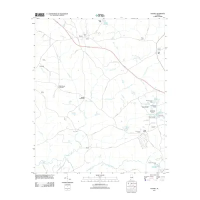
2011 Map of Waverly
USGS Topo · Published 2011About this map
Waverly and the surrounding Lee County countryside are documented here in a transition from traditional agricultural life to specialized research and water management. The area is defined by its numerous family and community burial grounds, including the Maddox Family Cemetery and Daniel-Caldwell Cemetery, which serve as anchors for local genealogy. Historically significant sites such as Jones Mill and Stephens Mill Pond point to an economy once driven by water-powered industry along the Loblockee Creek watershed. Modern land use is evidenced by the extensive Fisheries Research Unit Auburn University, featuring a complex system of ponds like Pond Number S-1 and Pond Number S-8. The map also captures several rural hubs including Gold Hill and Middle Brooks Crossroads, which highlight the enduring network of county roads connecting these small Alabama settlements.
Find a feature on this map
71 named features on this map. Tap any name to fly to it.
Don’t see what you’re looking for? This feature index may not catch every label — zoom into the map to look around manually.
Map Details
Editions of this 2011 Waverly Map
This is the sole edition of this map. No revisions or reprints were ever made.
Other maps of this area

1906 · Dadeville
USGS Topo · 1:125,000

1907 · Opelika
USGS Topo · 1:125,000

1909 · Opelika
USGS Topo · 1:125,000

1955 · Phenix City
USGS Topo · 1:250,000

1957 · Phenix City
USGS Topo · 1:250,000

1958 · Phenix City
USGS Topo · 1:250,000

1971 · Waverly
USGS Topo · 1:24,000
1971 · Moorefield
USGS Topo · 1:24,000
1971 · Opelika West
USGS Topo · 1:24,000

1971 · Loachapoka
USGS Topo · 1:24,000