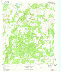
1967 Map of Wayland
USGS Topo · Published 1982About this map
The settlement of Wayland sits at the northern edge of this landscape, characterized by the winding tributaries of Gonzales Creek and several prominent peaks like Bald Mountain and Maxwell Mountain. The era's extractive industry is evident through the numerous Oil Wells and Gravel Pits scattered across the terrain. A notable piece of local history is preserved in the form of an Old Railroad Grade, which once navigated the uneven topography south of Lake Daniel.
Find a feature on this map
24 named features on this map. Tap any name to fly to it.
Don’t see what you’re looking for? This feature index may not catch every label — zoom into the map to look around manually.
Map Details
Editions of this 1967 Wayland Map
2 editions found
Other maps of this area

1890 · Breckenridge
USGS Topo · 1:125,000

1894 · Eastland
USGS Topo · 1:125,000

1954 · Abilene
USGS Topo · 1:250,000

1958 · Abilene
USGS Topo · 1:250,000

1961 · Buck Mountain
USGS Topo · 1:24,000

1966 · Cisco North
USGS Topo · 1:24,000

1966 · Eastland
USGS Topo · 1:24,000

1966 · Ranger
USGS Topo · 1:24,000
1967 · Wayland
USGS Topo · 1:24,000

1967 · Necessity
USGS Topo · 1:24,000