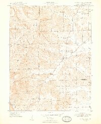
1948 Map of Waymansville
USGS Topo · Published 1948About this map
The borderlands of Brown and Bartholomew counties are defined here by a network of rural settlements and hilltop landmarks just after the war. Waymansville serves as a central point of reference near the confluence of South Fork White Creek and White Creek, while the surrounding landscape is dotted with local institutions like Ohio Chapel, White Chapel, and Taylor Chapel. The map reveals the community structure of the late 1940s, where small schoolhouses such as Conner Sch and Dettmer Sch were still prominent features on the landscape. The terrain is notably marked by Gilmore Hill and Dug Hill, showing the elevation changes that shaped the placement of roads and farmsteads. This survey captures the transition of the region before modern consolidation, preserving the locations of numerous small family burial grounds like Weddell Cem and Phillips Cem across Van Buren, Pershing, and Hamilton townships.
Find a feature on this map
41 named features on this map. Tap any name to fly to it.
Don’t see what you’re looking for? This feature index may not catch every label — zoom into the map to look around manually.
Map Details
Editions of this 1948 Waymansville Map
2 editions found
Other maps of this area

1942 · Franklin
USGS Topo · 1:125,000

1942 · Columbus
USGS Topo · 1:125,000

1947 · Nashville
USGS Topo · 1:24,000

1948 · New Bellsville
USGS Topo · 1:24,000

1948 · Waymansville
USGS Topo · 1:24,000

1949 · Nashville
USGS Topo · 1:24,000

1953 · Cincinnati
USGS Topo · 1:250,000

1953 · Indianapolis
USGS Topo · 1:250,000

1956 · Indianapolis
USGS Topo · 1:250,000

1956 · Story
USGS Topo · 1:24,000