
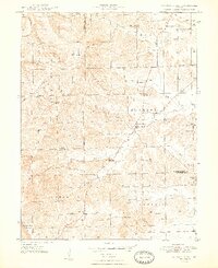
1948 Map of Waymansville
USGS Topo · Published 1948About this map
Waymansville and the rural townships of Ohio, Jackson, and Pershing anchor this landscape at the intersection of Bartholomew, Brown, and Jackson counties. The terrain is defined by its deep drainage networks, with the South Fork White Creek and Salt Creek carving through the ridgelines near Gilmore Hill and Dug Hill. This mid-century survey shows a community defined by its local institutions, with numerous country schools like Conner Sch and Dettmer Sch serving families in the surrounding hills.
Find a feature on this map
41 named features on this map. Tap any name to fly to it.
Don’t see what you’re looking for? This feature index may not catch every label — zoom into the map to look around manually.
Map Details
Editions of this 1948 Waymansville Map
2 editions found
Other maps of this area

1942 · Franklin
USGS Topo · 1:125,000

1942 · Columbus
USGS Topo · 1:125,000

1947 · Nashville
USGS Topo · 1:24,000

1948 · New Bellsville
USGS Topo · 1:24,000

1949 · Nashville
USGS Topo · 1:24,000

1953 · Cincinnati
USGS Topo · 1:250,000

1953 · Indianapolis
USGS Topo · 1:250,000

1956 · Indianapolis
USGS Topo · 1:250,000

1956 · Story
USGS Topo · 1:24,000

1956 · Vincennes
USGS Topo · 1:250,000