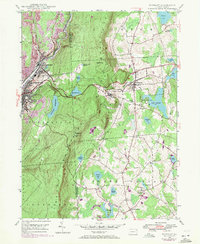
1946 Map of Waymart
USGS Topo · Published 1971About this map
The Clinton Mountains and Moosic Mountains dominate this 1946 topography, forming a high, wooded barrier between the anthracite industrial centers and the farming plateaus to the east. In the west, Carbondale and Simpson sit along the Lackawanna River, where the landscape is heavily marked by strip mines and the busy corridors of the Delaware and Hudson Railroad. These industrial sites contrast sharply with the eastern half of the map, which centers on the borough of Waymart and the rural crossroads of South Canaan.
Find a feature on this map
41 named features on this map. Tap any name to fly to it.
Don’t see what you’re looking for? This feature index may not catch every label — zoom into the map to look around manually.
Map Details
Editions of this 1946 Waymart Map
4 editions found
Other maps of this area

1889 · Scranton
USGS Topo · 1:62,500

1891 · Scranton
USGS Topo · 1:62,500

1892 · Honesdale
USGS Topo · 1:62,500

1892 · Dundaff
USGS Topo · 1:62,500

1893 · Scranton
USGS Topo · 1:62,500

1928 · Ariel
USGS Topo · 1:62,500

1932 · Ariel
USGS Topo · 1:62,500

1943 · Scranton
USGS Topo · 1:125,000

1943 · Honesdale
USGS Topo · 1:125,000

1946 · Olyphant
USGS Topo · 1:24,000