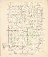
1936 Map of Wayne Co Airport
USGS Topo · Published 1936About this map
The Wayne County Airport stands as a central landmark in this 1930s landscape, serving as a focal point for the developing townships of Romulus, Taylor, Huron, and Brownstown. This unedited advance sheet reveals an area defined by an intricate network of agricultural drainage, with dozens of named channels like the Sloss & Ganong Drain and Brest Drain crisscrossing the terrain. Settlement patterns are sparse but established, centered around local hubs like Taylor Center and Brighton.
Find a feature on this map
82 named features on this map. Tap any name to fly to it.
Don’t see what you’re looking for? This feature index may not catch every label — zoom into the map to look around manually.
Map Details
Editions of this 1936 Wayne Co Airport Map
This is the sole edition of this map. No revisions or reprints were ever made.
Other maps of this area

1905 · Wayne
USGS Topo · 1:62,500

1905 · Detroit
USGS Topo · 1:62,500

1906 · Wyandotte
USGS Topo · 1:62,500

1906 · Romulus
USGS Topo · 1:62,500

1912 · Wyandotte
USGS Topo · 1:62,500

1912 · Wayne
USGS Topo · 1:62,500

1918 · Detroit
USGS Topo · 1:62,500

1924 · Detroit
USGS Topo · 1:62,500

1928 · Romulus
USGS Topo · 1:62,500

1929 · Wyandotte
USGS Topo · 1:62,500