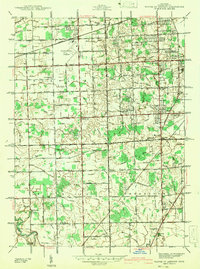
1942 Map of Wayne Co Airport
USGS Topo · Published 1942About this map
Wayne County Airport dominates the northern landscape of this 1942 survey, reflecting the region's mid-century transition from agrarian townships to aviation and industrial centers. The surrounding terrain in Romulus Township, Taylor Township, and Brownstown Township is defined by a dense network of drainage channels such as the Sexton and Kilfoil Drain and English Drain, necessary for managing the flat, low-lying plains of Wayne County. Local life centers on numerous country schools like Woodville Sch and Hand Sch, while the Wabash RR cuts diagonally across the northern portion of the map, providing a vital transportation link. Scattered family-named settlements like Taylor Center and Brighton appear as small clusters of homes and businesses along primary thoroughfares such as Telegraph Road and Goddard Road. Down toward the Huron River, the landscape remains largely rural, dotted with landmarks like the Sand Hill and Krause Cem.
Find a feature on this map
82 named features on this map. Tap any name to fly to it.
Don’t see what you’re looking for? This feature index may not catch every label — zoom into the map to look around manually.
Map Details
Editions of this 1942 Wayne Co Airport Map
This is the sole edition of this map. No revisions or reprints were ever made.
Other maps of this area

1905 · Wayne
USGS Topo · 1:62,500

1905 · Detroit
USGS Topo · 1:62,500

1906 · Wyandotte
USGS Topo · 1:62,500

1906 · Romulus
USGS Topo · 1:62,500

1912 · Wyandotte
USGS Topo · 1:62,500

1912 · Wayne
USGS Topo · 1:62,500

1918 · Detroit
USGS Topo · 1:62,500

1924 · Detroit
USGS Topo · 1:62,500

1928 · Romulus
USGS Topo · 1:62,500

1929 · Wyandotte
USGS Topo · 1:62,500