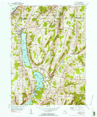
1953 Map of Wayne
USGS Topo · Published 1954About this map
Waneta Lake and Lamoka Lake dominate this central New York landscape, which is defined by the steep glacial valleys of the Finger Lakes region. Situated along the boundary of Steuben and Schuyler counties, the map records rural life in the mid-1950s through small settlements like Wayne, Tyrone, and Altay. Local infrastructure includes the District No 8 School and social landmarks such as Camp Gorton on the eastern shore of Waneta Lake. The topography is meticulously detailed, showing prominent elevations like Stocking Hill and Tyrone House ridge. In the south, Mud Creek flows from the lakes toward Mill Pond, while the northern portion captures a segment of Keuka Lake. This survey provides a precise account of the area's roads and land use before late-20th-century development altered the character of these lakeside communities.
Find a feature on this map
44 named features on this map. Tap any name to fly to it.
Don’t see what you’re looking for? This feature index may not catch every label — zoom into the map to look around manually.
Map Details
Editions of this 1953 Wayne Map
2 editions found
Other maps of this area

1898 · Watkins Glen
USGS Topo · 1:62,500

1901 · Watkins
USGS Topo · 1:62,500

1902 · Ovid
USGS Topo · 1:62,500

1903 · Penn Yan
USGS Topo · 1:62,500

1903 · Hammondsport
USGS Topo · 1:62,500

1905 · Watkins Glen
USGS Topo · 1:125,000

1942 · Pulteney
USGS Topo · 1:31,680

1942 · Dundee
USGS Topo · 1:24,000

1942 · Keuka Park
USGS Topo · 1:24,000

1943 · Keuka Lake
USGS Topo · 1:31,680