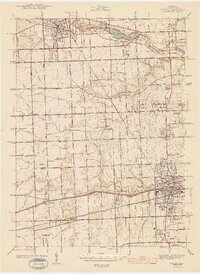
1943 Map of Wayne
USGS Topo · Published 1943About this map
Wayne and Plymouth anchor this survey of western Wayne County, conducted just as the region began its transition from a rural landscape to a vital suburban and industrial corridor. The Pere Marquette railroad cuts through the northern section, passing by Newburg Lake and the Triangle Airport, while the Lower River Rouge meanders through the central townships. The map is particularly rich in family and local history markers, recording a dense network of country schools such as the Canton Center Sch and Walker Sch, alongside numerous small burial grounds including Chubb Cem and Downer Cem.
Find a feature on this map
83 named features on this map. Tap any name to fly to it.
Don’t see what you’re looking for? This feature index may not catch every label — zoom into the map to look around manually.
Map Details
Editions of this 1943 Wayne Map
This is the sole edition of this map. No revisions or reprints were ever made.
Other maps of this area

1902 · South Lyon
USGS Topo · 1:62,500

1902 · Ypsilanti
USGS Topo · 1:62,500

1904 · Ann Arbor
USGS Topo · 1:125,000

1905 · Wayne
USGS Topo · 1:62,500

1906 · Ypsilanti
USGS Topo · 1:62,500

1906 · South Lyon
USGS Topo · 1:62,500

1906 · Romulus
USGS Topo · 1:62,500

1908 · Ann Arbor
USGS Topo · 1:125,000

1912 · Wayne
USGS Topo · 1:62,500

1928 · Romulus
USGS Topo · 1:62,500
Featured Places
- Canton Township, MI
- Canton Charter Township, Canton Township
- Livonia, MI
- Westland, MI
- Van Buren Charter Township, MI