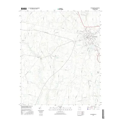
2017 Map of Waynesboro
USGS Topo · Published 2017About this map
The street grid of Waynesboro serves as the central hub of this East Georgia survey, where traditional town planning meets the agricultural landscape of Burke County. A high concentration of burial sites, including the Waynesboro Confederate Memorial Cem, Quinnie Cem, and Gray Family Cem, provides significant data for genealogists tracing local family lineages. The landscape is defined by its water systems, from larger bodies like Johnson Lake and Murray Lake to the meandering courses of McIntosh Cr and Rocky Cr. Outside the town center, small clearings such as Regan Landing and the Burke County Airport show the area's modern infrastructure. The map documents a territory where rural farm roads like Story Mill Rd and George Massey Rd connect isolated homesteads to the municipal core, preserving the spatial relationship between the county seat and its outlying countryside.
Find a feature on this map
96 named features on this map. Tap any name to fly to it.
Don’t see what you’re looking for? This feature index may not catch every label — zoom into the map to look around manually.
Map Details
Editions of this 2017 Waynesboro Map
This is the sole edition of this map. No revisions or reprints were ever made.
Other maps of this area

1919 · Gough
USGS Topo · 1:62,500

1920 · Millen
USGS Topo · 1:62,500

1920 · Greens Cut
USGS Topo · 1:62,500

1943 · Greens Cut
USGS Topo · 1:62,500

1943 · Millen
USGS Topo · 1:62,500

1943 · Augusta East
USGS Topo · 1:125,000

1943 · Millen
USGS Topo · 1:125,000

1947 · Savannah
USGS Topo · 1:250,000

1948 · Savannah
USGS Topo · 1:250,000

1948 · Gough
USGS Topo · 1:62,500