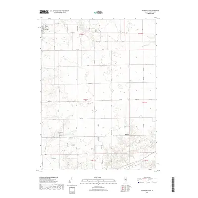
2018 Map of Waynesville East
USGS Topo · Published 2018About this map
Waynesville occupies the northwestern corner of this DeWitt County landscape, serving as the primary hub for a region defined by agricultural grids and wandering creek beds. The drainage of Rock Cr and Deer Cr cuts through the northern sections, while Tenmile Cr flows across the southern portion near the Gibson Lakes. This environment is a classic example of Illinois prairie development, where a rectilinear road network, including the prominent Waynesville Rd and Thorps Rd, facilitates access to isolated farmsteads and rural landmarks. Several burial grounds, including Evergreen Cem and Rock Creek Cem, provide important genealogical markers for long-standing local families. The presence of the Hooterville Airport north of Tenmile Cr highlights the integration of modern small-scale aviation into this traditional farming community.
Find a feature on this map
60 named features on this map. Tap any name to fly to it.
Don’t see what you’re looking for? This feature index may not catch every label — zoom into the map to look around manually.
Map Details
Editions of this 2018 Waynesville East Map
This is the sole edition of this map. No revisions or reprints were ever made.
Other maps of this area

1949 · Mc Lean
USGS Topo · 1:62,500

1951 · McLean
USGS Topo · 1:62,500

1951 · Le Roy
USGS Topo · 1:62,500

1957 · Kenney
USGS Topo · 1:62,500

1957 · Maroa
USGS Topo · 1:62,500

1958 · Peoria
USGS Topo · 1:250,000

1961 · Peoria
USGS Topo · 1:250,000

1963 · Peoria
USGS Topo · 1:250,000
1979 · Maroa
USGS Topo · 1:24,000
1979 · Clinton
USGS Topo · 1:24,000